
Demystifying the
Spatial Planning Process
in Indian Cities
Measuring how planning
systems work—and where they
must improve.
The Spatial Planning Index (SPI) is UDRI’s flagship initiative to assess how effectively spatial planning systems operate across regions. It evaluates key dimensions including policy frameworks, institutional capacity, data systems, and public engagement to uncover how planning translates into real-world outcomes.
Demystifying the Spatial Planning Process in Indian Cities
India is experiencing exponential urban growth. It is estimated that by 2050, more than 50% of India’s population will reside in urban areas, up from 31.2% in 2011. This means that there will be millions of new urban residents in India. Currently, India has 8 megacities with a population of over 6 million, 97 metro cities (with a population between 1 and 6 million), and 7933 towns and census towns. It is expected that not only will more people live in the existing cities and towns but also that the number of urban areas will increase. Urbanization represents a massive economic and human development opportunity for India. However, with urbanization happening at this rate and scale, the important question is how Indian cities can handle this urban growth.

To tackle urban growth and development, the Indian constitution, through its 74th Amendment in 1992 and the Model Regional and Town Planning0 and Development Law 1985, designates urban governance responsibilities at different levels and assigns urban planning as a state subject to be entrusted to urban local bodies (ULBs). On these lines, several Indian states have legislated their respective town planning acts, which mandate the spatial planning process in the state. Along with the state legislation, several central schemes, such as the Atal Mission for Rejuvenation and Urban Transformation (AMRUT) and Smart City Mission, also support a city’s urban initiatives. All these mechanisms together guide spatial planning in cities, and they need to work cohesively to make liveable and resilient places.
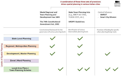
The spatial planning process comprises the regional planning and master planning process, typically guided by the state town and country planning act; the zonal or local area plans, typically guided by a combination of state legislation and central schemes. The spatial planning process is complex and not the same for each city. The on-ground realization of these legislations and schemes has its own challenges, leading to each city coping in its own unique ways. Additionally, different cities are in various stages of realizing their spatial plans. Although master planning is one of the main process within the overall spatial planning process that guides how cities are shaped, it is startling to know that 65% of the total urban areas in India do not even have a master plan itself (NITI Aayog 2021).
While the urban spatial planning landscape is still evolving, there is a huge national momentum to streamline this process. Various committees and experts have been appointed at higher levels to deliberate on the issues and roll out planning-focused initiatives. However, there is an urgent need to capture on-ground learnings from different states and cities, as each area has distinct challenges and some have devised different and unique ways to navigate through the challenges of implementing spatial planning practices at various levels. This state-by-state learning database is critical to understand good practices and create a platform to facilitate grassroot level cross-learning from each of our different states. Additionally, documentation of the best practices would help compile a robust methodology and momentum for legislative changes.
The project ‘Demystifying the Spatial Planning Process in Indian Cities’ aims to capture on-ground learnings from a sample set of 37 plus Indian cities across 28 states and 4 union territories as they navigate the spatial planning process guided by state legislation and central schemes.
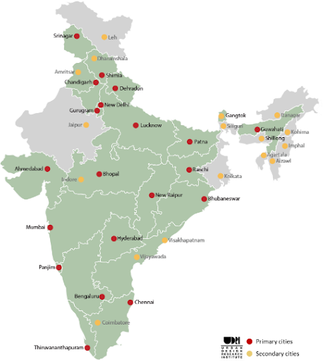
UDRI was extensively involved with Mumbai’s master planning (DP 2034) process for fourteen years. We captured our learnings from this process as a roadmap of engagement for other cities where masterplans are being made (this is documented in detail in the chapter, Learning from the Mumbai DP 2034 Engagement Process). However, as each city’s context is different we realise a need to work in qualitatively different urban areas. Therefore, we conducted detailed mapping of the spatial planning process (within which master planning is one of the stages) in 2 additional pilot cities, Patna and Srinagar. We developed an analytical framework for mapping and comparing the spatial planning structure and formulated a matrix to organize our learnings. Currently, UDRI is in phase I of this comparative study, with main objectives to capture
- Best practices from the field that can be replicated
- Challenges in the realization of the framework
- Inventory of methodologies and tools of planning
The learnings are collated under five categories:

Planning Legislation

Organization Structure

Planning Process

Coordination and Monitoring

Capacity Building

Citizen Participation
The framework for the comparative analysis is shown in Figure 3. The framework explains the various spatial planning levels, followed by the statutory provisions for the administrative bodies and planning documents.
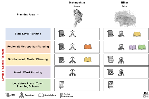
The figure above shows a comparative analysis of the two pilot cities, Mumbai and Patna. In Mumbai, the Maharashtra Regional and Town Planning Act of 1966 mandates the spatial planning levels at regional and municipal levels. It also designates a metropolitan development body to prepare a regional plan and a municipal administrative body to prepare a master plan. Similarly, in Patna, The Bihar Urban Planning and Development Act 2012 mandates spatial planning levels at municipal, zonal/ward, and local areas. However, unlike Mumbai, the preparation of planning documents is to be done by the non-designated planning bodies, i.e., a master plan is prepared by the state government and zonal/ward and local area plans are made by the metropolitan development body. This variation in the spatial planning process of Mumbai and Patna leads us to some essential observations, such as that the sanctioned regional plan for the Mumbai Metropolitan Region (MMR), which encompasses the larger vision for the infrastructural and economic development of the city, is absent in Patna, and while zonal/ward and local area plans are directed toward solving local challenges and issues in Patna, they are not being made in Mumbai.
In addition to the comparative analysis, there were other interesting observations during our field visits to various Indian cities. Some of these observations are being captured as examples of best practices and organized under the five learning categories mentioned above. An important example captured under the capacity building category is from the state of Punjab, where local capacity building in GIS-based master planning is being incubated. Non-statutory planning organizations, especially local universities, are consulted and heavily involved in various capacities for the spatial planning process, such as the Guru Nanak Dev University, Punjab, which has been involved in creating and updating GIS-based master planning data for the state. Planning professionals from within the state are getting trained in handling their own state’s GIS data. The university also provides a large number of young planners to the various state planning bodies within and outside Punjab.
The final outcome of the project is to use the learnings from the comparative study for the larger level (national and sub-national) discussion and consultation to validate learnings and build momentum towards more significant policy changes and a nudge towards establishing robust planning systems at various planning levels.
Learnings from our studies across India will craft a general approach to enhance the role of non-statutory planning organizations, such as educational institutions and urban research think tanks, to be actively involved in the master planning process and provide opportunities for local capacity building. This is an essential part of the project to identify local vested voices that can be strengthened to play a sustained role in their areas' spatial planning journey.
Reports
Progessing Urban Development
UDRI’s Spatial Planning Index 2024
<> Will cover 75 cities across Maharashtra, significantly expanding the scale and depth of analysis.

Progessing Urban Development
Uttar Pradesh Advisory Note 2025
<> Will cover 75 cities across Maharashtra, significantly expanding the scale and depth of analysis.
Gallery
View All Images
Related Projects
Reimagining Mumbai's Eastern Waterfront
Unlocking the Potential of Mumbai's Historic Port Lands Through Integrated Urban Regeneration
Digital Inclusion
Making Urban Data Accessible for Better Planning
Refurbishment and Upgradation of MG Road, Fort, Mumbai
Transforming Historic Streets Through Heritage Sensitive Urban Design